Showing posts with label professional. Show all posts

Sunday, October 13, 2013

Conflicting Knowledge...

Of interest to me is the concept of how markets are created in a free market enterprise. In the past, leadership was presented at the highest levels of our government mainly through the leadership of our president and their agenda. However, since the Clinton/Lewinsky fallout the presidency has become something different. The office was recognized as the leadership position for our country but over time it seems only recognized as the leader of the opposing party.

This situation has stagnated our economy. Even with the recognition of a shift to technology markets resulting from environmental concern our markets have struggled under the abdication of our political structure. The structure is not new - it has existed well over two hundred years but without a defined position of leadership the country focused only on security once jolted by 9/11.

After the cooperation of creating the largest expansion of government in the history of our country (security)  there was a let down in any follow up activities needed  to  create new markets. This has led to the questioning of one of the pillars of our country - economic analysis. The historical capabilities of this embedded profession in the heart of our government now bears the burdon of recognizing emerging markets.

We see new technology trying to emerge but with political paralysis and a profession mired in its historical boundaries we will soon find ourselves in an unusual position - 2nd place. Is this is reason enough to begin using our technical skills that has historically been known as human geography? But this road too is not paved or easily navigated in our country. The reason is that human geography in the United States has a very small presence only  apparent in zoning activities.

The road ahead however is not impassable. This is mainly due to another historical connection with our government - the support of our institutions for higher learning. It began through the efforts of the Department of Homeland Security who forged relations with college's throughout the country focused on visual analytics. Visual analytics has grown as a supporting effort to the security situation arising out of 9/11 and has been solidified in the conflicts of Iraq and Afghanistan. But it's focus now needs to turn in support of long term analysis.

How will this new convergence look - an age old profession with emerging capabilities that are for the most part incompatible due to opposing theologies? Our historical economics has been labeled "Cowboy Economics" while emerging technologies are known as toys or entertainment but recognized for their possibilities in "Game Theory".

All of this is lost in the political environment perpetuated by 24 hour news steeped in entertainment. In addition bloggers and writers seem content to fan the conflict and act as if the only solution is the dualistic approach. We now see Tweeter and Facebook used as sources of news while the academics struggle to integrate "toys" into a serious system that brings together opposing knowledge systems - what are they you ask? The PAST and the FUTURE.

Saturday, August 24, 2013

VOODOO:-)

Woke up this morning with a word in my head - SAYERGOES – its not even a word. So I Googled it. Nothing too interesting until... there it is. A BOOK - "Contested Worlds: An Introduction To Human Geography" by Martin Phillips. Gotta get it. The link went right to page 50 and this is what I read. CRAZY VOODOO:-)

Read the first two paragraphs on page 50 and decided to buy it. The concepts align perfectly with some of the ideas I've had in the past and I look forward to expanding on these ideas...

New Humanism?

Enjoyed the realistic description of  "Economic Man" - it sings of a deep look into the processes that have been relied upon for eons. I am very much surprised that the gentleman is from the U.S. but he is also a Landscape Architect. It seems to me that in the U.S. the notion of "Human Geography" is not as prevalent as in Europe but our Landscape Architect professionals seem to embody an overlapping interest.

http://www.metropolismag.com/Point-of-View/February-2013/A-New-Humanism-Part-9/

Monday, July 8, 2013

What the EXIF?

There are many software tools available for geotagging pictures but once you add all the different ways to do it and multiply it by all the GPS log synchronization methods, they are very technical programs. Of them all GeoSetter seems the most complete and capable. However, after tinkering for a while and narrowing the method to synchronizing a directory of pictures to a Garmin GPX log file, it was easier done with the ExifTool by Phil Harvey.


The ExifTool is used by GeoSetter and many other geotagging software tools - it's a very capable command line program by itself. With a little reading of the well documented functionality on the web site , I did the following:

  1. Created a directory with copies of my pictures. 
  2. Created a copy of my GPX file "tracks.gpx"  in the same directory. 
  3. Copied the downloaded "exiftool.exe" there also.
  4. Then created a "Geotag.bat" file with the line below and geotagged all my images.
REM ##########################################################################
exiftool -geotag tracks.gpx -geosync=+00:56 -City="Boone" -Sub-Location="Appalachian State University" -Province-State="North Carolina" -Country-PrimaryLocationName="USA" *.jpg

pause
REM ##########################################################################

ExifTool even allows for exporting a Google KML file using a template but this diverged from my simplistic theme. The exported KML file still needs to have the images read from a Web site to work in Google Earth. GeoSetter has the best KML export capability but it still seemed best to have the original image on a Web site.

There are a lot of web portal options for geotagged images. GeoSetter has built in publishing support for LocRMaps (http://www.locr.com) but I didn't feel like a new sign up. I knew my EveryTrail ( http://www.everytrail.com) web site would work but had read in passing that Microsoft SkyDrive and Google Picasa both supported geotagged images without making any new accounts.


All the sites were relatively easy to upload files but Google Picasa handled the 261 geotagged photos the best. EveryTrail is suited strictly for trails with photos as a feature but SkyDrive and Picasa are for pictures with maps as a  feature. SkyDrive is more graphically refined but Picasa has more mapping features. For map production from geotagged pictures Picasa wins hands down.


As you navigate to the project folder in Picasa's web album, you immediately know the photos are geotagged because of an overview map on a right side panel. The overview map can be zoomed and basemap changed to satellite or terrain. Immediately below the overview map are two additional mapping options - View map and View in Google Earth. Others options include web links, RSS feed, album sharing and embedded code for an animated web album.

This isn't the end of it though - still have to pull it all together in a GIS system. I'm sure it will provide a few more options:-)

Sunday, July 7, 2013

Picasa Geotagged Web Album...

Geotagging Project...

This week I had an opportunity to get back to geotagging photos in a very big way - it wasn't a bicycle trip but a field trip with work. It was spur of the moment but I grabbed a Garmin eTrex Vista (HCx) and a Panasonic Lumix DMZ-LZ8k and knew I was going to be geotagging. Purchased the work equipment a number of years ago due to its functionality - it performed flawlessly. A built in GPS cameras does not seem practical to me but, at the same time, geotagging is NOT easy. I didn't have time to catchup on the process but grabbed the equipment and a handful of batteries as I left the office.

Did not synchronize the GPS and camera clock but I did take a picture of the GPS as I got out of the car. This way I could synchronize the GPS log file with the picture time later. Turned out that I took about 160 pictures and about 90 waypoints without any problems except that the camera ate batteries. Finally adjust the screen settings so they would last longer.


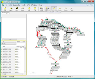
Couldn't wait to get back to the hotel and play with the data. Nothing appeals to me more than maps and pictures but my time away from the equipment showed. The very first issue was not accessing the waypoints - I could connect to the GPS using USB but the GPX file only contained the log files. I wanted ALL the waypoints too. Oh yeah - they had to be in the internal memory, so I downloaded EasyGPS (http://www.easygps.com). If you have a Garmin this software is a must. It connects directly and is able to read all the data flawlessly. It even geotags photos but the camera has to be time synchronized prior to using. That's where I messed up - not taking the time to check the time. There was even a daylight savings time issue with the camera.


Had used GeoSetter (http://www.geosetter.de/en/)  way back with my original research so I downloaded it right away. As before it was very comprehensive but not as intuitive as I remembered. I was able to get some pictures and maps but there were so many options and settings that I wasn't comfortable with the output. Also, there was one picture that wasn't showing where I knew it to be. Time for something new. Geotag (http://geotag.sourceforge.net) popped up on one of my searches and I had not seen it before. Actually had download a few others but they were as complex as GeoSetter so I didn't use them. However, Geotag is a Java program and one of our data loggers also uses a Java program I liked a lot but it's proprietary to the logger. Liked the concept.


Took a few times to get the geotagging working on my photos. Geotag requires two other programs to work - GPSbabel (http://www.gpsbabel.org) and EXIFtool (http://www.sno.phy.queensu.ca/~phil/exiftool). Didn't really like that because GPSbabel requires a Windows install but it looks like it may take the place of EasyGPS for connecting to the Garmin. Also, Geotag needs to know these external program locations and it asks for their directory. Didn't work the first couple of times because it actually needs the executable with path location.


Geotag has an intuitive interface so it didn't take long to figure it out. Once the pictures were added it was like working in a spreadsheet with right-mouse-click context menu's. I found it the simplest and easiest to adjust the time on my picture. Geotag prompts you with a menu option to "Set time of image..." so I went to my GPS picture and set the time to match - "easy peasy".

What I found out in this entire process was that there are way more options for geotagging pictures and I need to do some more testing. GPSbabel looks like a good solution too and I haven even got to the map output. Back when I researched the original process there wasn't a lot of map options but now Google Picasa and Microsoft SkyDrive both support geotagged photos. Oh well - looks like a new project:-)

Wednesday, June 5, 2013

FEMA's Quick 2 version 1

FEMA's Web site lists software authorized for use with its NFIP FIRM mapping  program but although it lists Quick 2 version 1 when the links are navigated you end up at version 2. Both are old programs but their importance is expressed in their name - QUICK!

Quick 2 is the latest but can only be described as finicky on all current Windows platforms. It's also seems more so when loaded on computers with other Corps of Engineers HEC versions. For this reason I began using Quick 2 version 1. Version one is DOS based but is very stable and works with no clitches.

Unfortunately with the upgrade of operating systems to Windows 7 64bit Quick 2 version 1 became obsolete. Seemed a waste of a perfectly good program that did everything it was designed to do except look modern.

With a little research DOSBOX was found -  it is a popular program used to play old DOS games on current systems, including 64bit Windows 7. It took very little effort to get it running and its something you may need can be downloaded here.

If this is something you need just email me..

http://www.fema.gov/software

http://www.fema.gov/national-flood-insurance-program-0/quick-2-version-10

http://www.fema.gov/library/viewRecord.do?id=2316